
A Pulitzer Prize-winning newspaper
 This is shaping up to be one of the most chaotic summers in history for tornadoes in Iowa. A normal summer sees about 200 tornadoes across middle America. Forecasters fear there may be double that number this year in “Tornado Alley.”
We’ve seen several catastrophic tornadoes already in Iowa this year. Just a few weeks ago the picturesque central Iowa town of Greenfield was nearly blown off the map by a particularly deadly twister.
The one bright spot is that weather forecasting has evolved so much in recent years that tornado activity in specific areas can be forecast pretty accurately hours ahead of time. On the morning of May 21, meteorologists were already warning of the dangers to come in south central Iowa later that afternoon.
This gives me my annual opportunity to dust off my files and relate my 15 minutes of fame, when I photographed the tornado that destroyed much of Algona on the evening of June 28, 1979. Back then, tornadoes could not be accurately forecast. We were lucky to get about 15 minutes warning of the tornado that tore through Algona shortly after 7 p.m. on that muggy Thursday evening.
Tornado warnings then were generally only issued when one was actually seen on the ground. That was the case for this one in Kossuth County, which started near Fenton, about 20 miles northwest of Algona. Because of the early warning, only two people died in Algona, but another tornado out of the same system that night killed three people in Manson, about 50 miles south.
The Algona tornado was later classified as F3 and Manson’s was rated as F4, the same intensity as the twister that hit Greenfield this year. F5 is the worst. There were 38 tornadoes that ran roughshod across the Midwest that night 45 years ago.
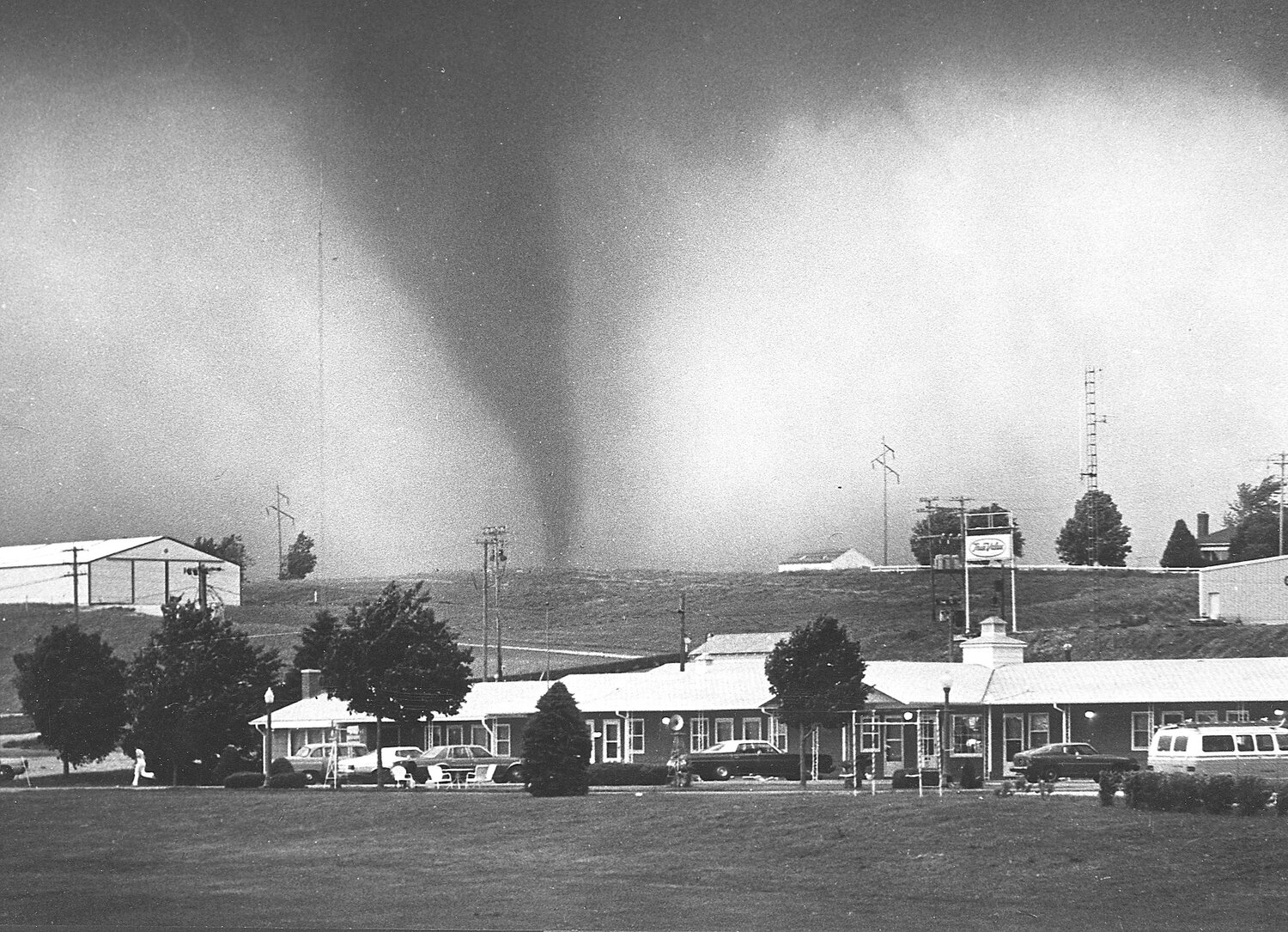
I was photographing a girls softball game between Algona High School and Garrigan High School at the Garrigan field on the northeast side of town when the tornado sirens began blaring. The teams and fans ducked for cover in the nearby basement of Garrigan High School while I hopped in my car and headed north to see where the action was. In about two minutes I came face to face with the awesome black funnel as it bore down into a shopping center at the corners of highways 18 and 169. I grabbed a few quick shots as the funnel cloud headed my direction when a man in a nearby cafe yelled at me to seek cover. I joined him and a dozen diners and restaurant workers in a crawl space under the kitchen of the cafe at the southwest corner of the intersection. I feared we were all going to die as we watched the twister smash the three corners surrounding us. Miraculously, our corner was spared.
The pictures I took were picked up by the Associated Press and published around the world. In those days, before ubiquitous cellphones, it was extremely rare to get a good — or even bad — photograph of a tornado. Now tornadoes are captured by everyone and their brother, not only stills but also movies and drone views.
The picture I took that received the most play was the one shown above, which captured a person running for their life as the tornado approached. Everything in this scene was flattened five minutes after this picture was taken. Semi trucks were flipped upside down. The person running escaped unhurt, but 34 people in town were injured — in addition to the two who died — and more than 120 homes were destroyed. The downtown was spared and, in a remarkable spirit of resiliency, the community celebrated Algona’s long-planned 125th anniversary a few days later with a parade down State Street. That’s Iowa Stubborn!
Before this tornado, I used to get annoyed when storm warnings interrupted TV shows I was watching. I got religion after that and now I pay attention when I hear weather warnings.
Tornado season is just getting started. Pay attention to the warnings.


Comments
No comments on this item Please log in to comment by clicking here